|
Bariloche y alrededores |
Origin of the Nahuel Huapí National Park:
The creation of the Nahuel Huapi national park (from the araucan words Nahuel: tiger, Huapi: island) goes in hand with the creation of the natural protected areas system. In 1903 doctor Francisco P. Moreno made a donation of 7.500 hectares of his property land, that he had received as prize for his free services to the National government in the Chilean - Argentine national border commission. He donated this land with the goal to preserve it natural state for future generations and the only allowed constructions made on this property is just to allow an easier access to the visitors of the natural areas. In 1922 was created the first national park, called "Del Sur" (Southern), with a 785.000 ha surface. In 1934 was created the National Park State office and the Nahuel Huapi National Park. It is an South Andean area with medium high mountains, glaciers, snow origin rivers, beautiful lakes, forests, valleys and some patagonian steppe
area.
Location:
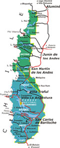
It is located at the southeast of Neuquén province, Los Lagos county and on the west end of Río Negro province, Bariloche county. It limits at north with Lanín national park, and includes Los Arrayanes national
park.
Regional geography:
The National Park Nahuel Huapi has its greater elevations on the Andean ridge, steeply lowering toward the east, in the patagonian plateau. The highest mark the limit with Chile, the highest one is the mount Tronador (3554 ms.) , It is called "tronador" (thunders) due to the sound that produce the enormous detachments of snow and ice. Other important mountains are Crespo, Cuyín Manzano, Campana, Milaqueo, Capilla, Cerro Santa Elena , Bastión, López and Catedral, with heights in between 1800 and 2400 ms. Deep valleys and cliffs, called 'pasos' (passes), permit the crossing toward Chile. The best known are Puyehue, Perez Rosales and Vuriloches, passes that were used by the natives. Just further east, in the preandean zone, the most prominent mountains are Otto, Ventana, Challhuaco, Ñireco and Ñirihuau ridge having all of them surprising panoramic views. On the South border of the park, we find the Manso river, one of the most characteristic of the zone, also we find lagoons such as: Negra, Schmoll, Toncek, Frías, Jacob, Ilón and lakes as the Mascardi, Guillermo, los Moscos, Hess, Fonck and Gutiérrez.
Nahuel Huapí national park eco-regions:
Given the different geographical relieves and the climatic variations, exists in the National Park 4 clearly defined
environments:
1) High Andean:
at more than 1.600 meters over sea level, the sandy-rocky soil, the low temperatures, the strong winds and intense snow do not permit a good development of the vegetation. Only grow small and dispersed forms of plants adapted to these rigorous conditions. Here it inhabits the majestic condor; the threatened huemul - Andean deer. The snow accumulated during the winter in this area of the Park, feeds the last glaciers and the delicate network of streams, rivers, lakes and lagoons.
2) Humid Forest:
Occupies the slopes and valleys, lower down the high Andean environment. In this area, with abundant rains and tempered climate, grow big trees such as the coihue and the lenga (that becomes reddish in autumn) forming dense forests. In drier places grows the cypress, and the ñire. These forests are inhabited by different mammals as the Pudú, the Huiña cat and the Mountain little monkey, but they are rarely seen. On the other hand, there are various amphibious and fowls commonly seen such as the Black Woodpecker, Chucao, Rayadito, southern canary, Huala or Macá, Seagulls, Cauquenes and Bandurrias. In the lower land forest, almost always humid, dominates the Colihue cane (bamboo) and diverse ferns. Toward the border with Chile it is the valdivian forest, with an exuberant vegetation of Coihue, Mañiú, Laurel and Alerce, lianas windup.
3) Transition Forest:
what characterizes this area are forest spots alternating with dry pasturelands, where the rains are not so abundant. The cordillera cypress is one of the most frequent trees. There is greater variety of animals than in the humid forest, because forest species live together with those which prefer the pasturelands of the steppe.
4) Steppe:
In this extensive area of wavy landscape, the strong winds and the shortage of rains in the summer, complicate the trees growth. Here there are some varieties of grass and small and hard leaf bushes. Despite the arid environment, some animals as guanacos, foxes, pumas and several species of lizards and mice, find here a favorable place for its
development.
Climate:
This area has continental cold climate with dry season. The temperatures and rainfall are unevenly spread in the area occupied by the park. An important variation of the rainfall goes from west to east, between the Chilean border and the Limay river. The temperatures lowers sharply from the foot of the mountains towards the summit. These climatic variations plus differences of soils, relieves and geomorphology, results in important changes in the vegetation and fauna.
In winter, the average temperatures are 2 centigrade degrees and in summer 18 degrees, with maximums of 27 and minimums of 9. Mostly common are winds blowing from the Northwest to Southwest, but in autumn it is not rare the wind blowing from the East with cold and dry weather.
In summer days are warm and sunny, with fresh nights, and scarce rains and predominant winds of the southwest. The day are long, there is sun light until 22 Hs.
In autumn days are fresh-tempered with cold nights. The temperature oscillates between 4 and 13 centigrade degrees. In this season there are intense rains.
In winter days are cold with snow fall. The temperatures oscillate between 0 and -10 C°.
In spring days are fresh beginning to extended and to elevate gradually the temperature, diminishing slowly the volume of rain fall. The nights are cold, maintaining the freshness during the day, temperatures oscillate between 7 and the 20 degrees toward end of the
season..
History:
There are traces of human life in Patagonia since the Upper Paleolithic age, about 30.000 to 10.000 years BC. Further on, in the Neolithic age, humans started to arrive at the Nahuel Huapi nearby area: from the South came the tehuelche people, from the east the puelche, and from the north the pehuenche; prevailing among them a peaceful form of coexistence, that ended in the XVII century with the 'araucanizing' process (conquest of the araucan people coming from Chile with more aggressive culture domination). Through this process, these native groups were absorbed by the mapuche or araucanian culture, which was stronger and more dominating, that came from southern Chile where it was pushed by the Spanish invaders.
Half century before, there were already rumors about the existence of a fabulous city that was built in gold and precious stones by a great lake, in the southern territories. Attracted by this stories missionaries and soldiers vainly went in search of this rich city. Many missionaries died in this region, killed by the southern aborigines. Missionaries such as: Nicolas Mascardi, Guillelmo, Elguea and Laguna.
The Mascardi lake was firstly discovered in 1791 by Fray Francisco Menéndez, but 125 years later the Francisco P. Moreno exploring the region gave this lake this name honoring the Italian missionary killed by the Indians.
In 1860, begin a new period of scouting expeditions from Chile by Cox, and from Argentina by Francisco Moreno. In 1879 with the Desert Campaign (Argentine army conquering war against the aborigines south of Colorado river) concludes the aboriginal control restoring peace to the region.
In 1895, Carlos Wiederhold installs the first general trading shop where years later would be San Carlos de Bariloche officially founded on the 3rd of May of 1902 by the Nahuel Huapí lake. A decade later the first route for car was opened, thanks to the visit of the former American president, Theodore Roosevelt; and in 1921 the first airplane arrived to Bariloche. Finally, a decade later arrived the first train. In 1936, thanks to the visionary ideas of Ezequiel Bustillo, there are built important works such as the today's Cathedral, the Civic Center and city hall, also the Hotel LLao LLao and the San Eduardo chapel, beginning to delineate the tourist vocation of the city.
In 1907 the first doctor arrived to San Carlos. He was a Belgian called José Emmanuel Vereertbrugghen and his wife, whose name would remain connected with the history of Bariloche and the south of Nahuel Huapí national park. Also their son Benito, an active cattle farmer and an expert conoceuor of the region, was hired by different personalities in scouting and exploring trips to the western border regions. Different names of mountains and streams are related to Benito's activity in the region. At first, the explorers of the region, considered that the Mascardi lake and Manso river pours its waters to the Atlantic basin, but it pours its waters to the Pacific ocean. This fact intensified the controversy about borders with Chile. Then after the arbitration of the British queen was taken as a border determining parameter the highest summits being the Tronador mountain the limit between both nations. (The parameters to define the borders with Chile are: highest summits and water dividing lines). After intense and long studies of the expert Francisco P. Moreno with the border Commission, arouse with the necessary supporting facts to preserve all this region of south Nahuel Huapi National Park for Argentina in detriment to the Chilean pretensions.
|
 |


